
To promote easy access to research data, BCSS has just published The University of Bergen Global Navigation Satellite System Data Collection in the repository DataverseNO.
The collection contains data from four global navigation satellite system receivers at four locations (Ny-Ålesund, Longyearbyen, Hopen, Bjørnøya). Signals from three satellite constellations are recorded: GPS, GLONASS and Galileo. Currently the collection contains 60-second data of scintillation and total electron content for the years 2013-2019. More data will be added in the future. A quick extract is shown in the image below.
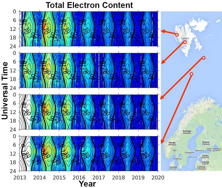
Summary of the total electron content (in colors) at each of the four sites versus Universal Time and Year. From 2013 there has been a steady decrease in the total electron content in the Earth’s ionosphere, which is related to a reduction in activity from max to min in the solar cycle.
These data are widely used for scientific publications. Some examples below include studies of the polar ionosphere and scintillation effects:
- dayside auroral forms [Oksavik et al., 2015]
- nightside auroral oval [van der Meeren et al., 2015]
- sun-aligned polar arcs [van der Meeren et al., 2016]
- auroral blobs [Jin et al., 2016]
- polar cap patches [Jin et al., 2017]
- polar holes [Jenner et al., 2020]
- geomagnetic storms [Prikryl et al., 2016; Jin and Oksavik, 2018]
- flow channels [Jin et al., 2019; Spicher et al., 2020]
- atmospheric gravity waves [Katamzi-Joseph et al, 2018]
- ionospheric irregularities [Fæhn Follestad et al., 2020]
More information on the data and its formats is found in the documentation data set.