

Photo: Kjartan Olafsson
To determine how Earth is coupled to space, we need to understand all the electrodynamics in the near-Earth environment. This includes an accurate description of the state of the ionosphere. In order to measure the ionospheric electrodynamics, there exist several instruments from both ground and space. However, while these instruments may provide valuable information on one specific part of the ionospheric state, none of them are able to provide the whole picture. E.g. ground networks of magnetometer stations give us one part of the electric current system, while magnetometers on satellites measure another part. Similarly, radars may measure the ionospheric flow of charged particles, while optical images and particle measurements can be used to estimate electric conductivity.
In a paper by Laundal et al. [2022] entitled “Local Mapping of Polar Ionospheric Electrodynamics“, they present a technique that combines all the different types of measurements to give a complete picture of what takes place in the ionosphere. The technique is named Lompe (Local mapping of polar ionospheric electrodynamics) and the source code may be found here. Lompe is tailored for use in regions where the data density is high, and the spatial resolution and extent of the analysis region are flexible.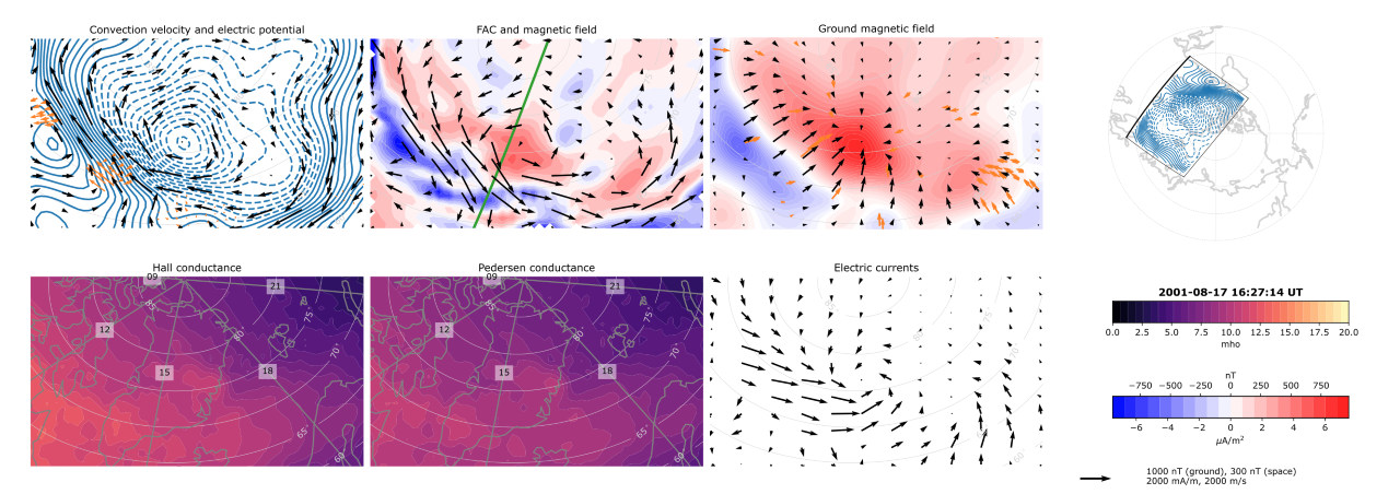 The image above is Figure 6 from Laundal et al. [2022], providing maps of convection, currents and magnetic field data in a region with good instrumental coverage. The orange arrows give convection measurements from radar (upper left) and ground magnetometers (upper right). These measurements, combined with auroral images, may be used to infer continuous maps of the ionospheric electrodynamics for the whole region.